


Pine Voting District, Ripley County, Missouri
About
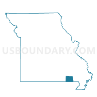
Outline

Summary
| Unique Area Identifier | 609555 |
| Name | Pine Voting District |
| County | Ripley County |
| State | Missouri |
| Area (square miles) | 68.48 |
| Land Area (square miles) | 68.47 |
| Water Area (square miles) | 0.01 |
| % of Land Area | 99.99 |
| % of Water Area | 0.01 |
| Latitude of the Internal Point | 36.73485510 |
| Longtitude of the Internal Point | -91.07514970 |
Maps


Graphs
Select a template below for downloading or customizing gragh for Pine Voting District, Ripley County, Missouri


Neighbors
Neighoring Voting District (by Name) Neighboring Voting District on the Map
- Eastwood Voting District, Carter County, MO
- Fremont Voting District, Carter County, MO
- Gatewood & Union Voting District, Ripley County, MO
- Johnson & Ozark Voting District, Oregon County, MO
- King Voting District, Oregon County, MO
- Shirley & Kelly Voting District, Ripley County, MO
Top 10 Neighboring County Subdivision (by Population) Neighboring County Subdivision on the Map
- Shirley township, Ripley County, MO (721)
- Gatewood township, Ripley County, MO (394)
- Kelly township, Carter County, MO (232)
- Pine township, Ripley County, MO (221)
- King township, Oregon County, MO (80)
- Ozark township, Oregon County, MO (70)
- Kelley township, Ripley County, MO (51)
Top 10 Neighboring Elementary School District (by Population) Neighboring Elementary School District on the Map
Top 10 Neighboring Unified School District (by Population) Neighboring Unified School District on the Map
Top 10 Neighboring State Legislative District Lower Chamber (by Population) Neighboring State Legislative District Lower Chamber on the Map
Top 10 Neighboring State Legislative District Upper Chamber (by Population) Neighboring State Legislative District Upper Chamber on the Map
- State Senate District 33, MO (184,118)
- State Senate District 3, MO (174,508)
- State Senate District 25, MO (169,588)
Top 10 Neighboring 111th Congressional District (by Population) Neighboring 111th Congressional District on the Map
Top 10 Neighboring Census Tract (by Population) Neighboring Census Tract on the Map
- Census Tract 4801, Oregon County, MO (3,749)
- Census Tract 8702, Ripley County, MO (2,958)
- Census Tract 9602, Carter County, MO (2,537)